Turn Gravity Forms Into a Powerful Search & Geolocation Platform
Collect location data, validate addresses, search and display Gravity Forms entries, calculate routes and distances, build interactive maps, and create directories, customer portals, store locators, and other location-aware experiences
Everything You Can Do with Gravity Geolocation
Everything you need to collect, validate, search, display, and visualize Gravity Forms data
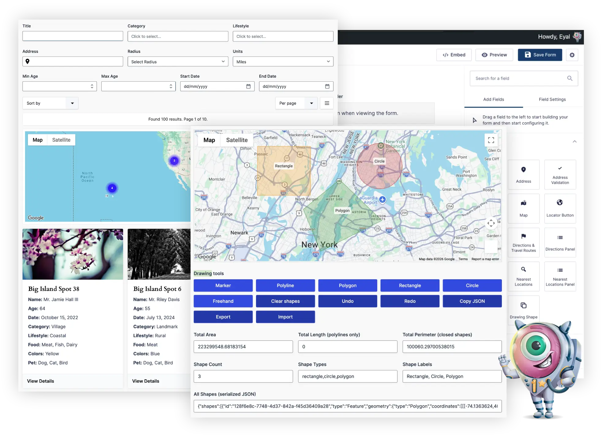
Search & Display Gravity Forms Entries
Search, filter, sort, and display Gravity Forms entries as cards, tables, maps, directories, customer portals, or custom frontend experiences.
Location Data Collection
Collect addresses, coordinates, maps, and user locations using native Gravity Forms fields.
Address Validation & Verification
Standardize addresses, verify deliverability, and improve data quality before submission.
Route & Distance Calculations
Calculate travel distance, duration, directions, and pricing directly inside your forms.
Interactive Maps
Display single locations, multiple submissions, or custom location data on interactive maps.
Nearest Location Search
Find the closest locations using driving distance, radius searches, or custom datasets.
Service Areas & Boundaries
Draw, edit, and store polygons, circles, and custom map shapes.
Native Gravity Forms Integration
Works with calculations, conditional logic, notifications, confirmations, and third-party add-ons.
Location-Aware Workflows
Build dynamic forms that respond to user location, distance, and geolocation data.
Popular Gravity Geolocation Solutions
Explore real-world solutions built with Gravity Geolocation

Search & Display Gravity Forms Entries
- Search by any Gravity Forms field, entry meta, user data, or geolocation field
- Filter by location, dates, users, categories, Gravity Forms fields, entry meta, and more
- Display results as cards, tables, lists, or maps
- Build custom frontend experiences without moving or duplicating your data
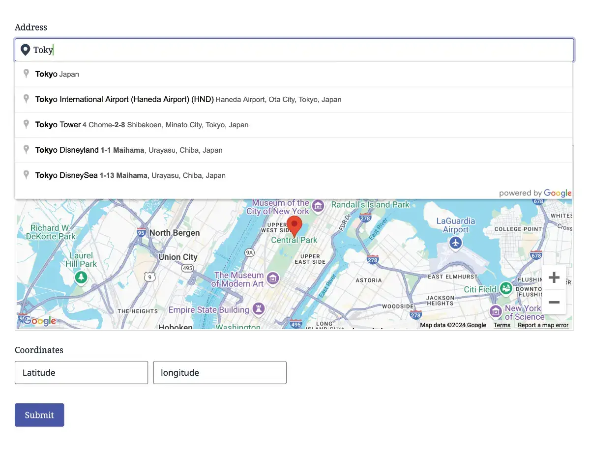
Geolocation Fields for Gravity Forms
- Address Field with Autocomplete for accurate inputs
- Coordinates Field for capturing latitude and longitude
- Locator Button for quick user location detection
- Map Field for visual location selection
- Multiple geolocation field groups
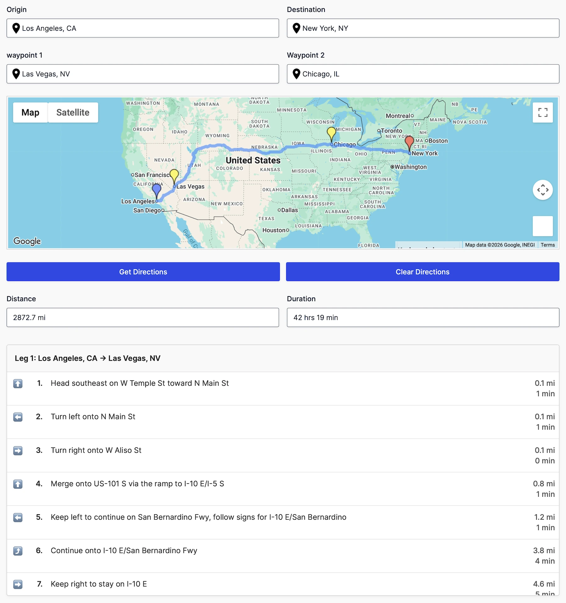
Calculate Routes, Distance & Travel Time
- Calculate travel distance and duration between locations
- Display turn-by-turn directions and routes on interactive maps
- Power pricing, quotes, and delivery calculations using distance data
- Support multiple waypoints, travel modes, and route preferences
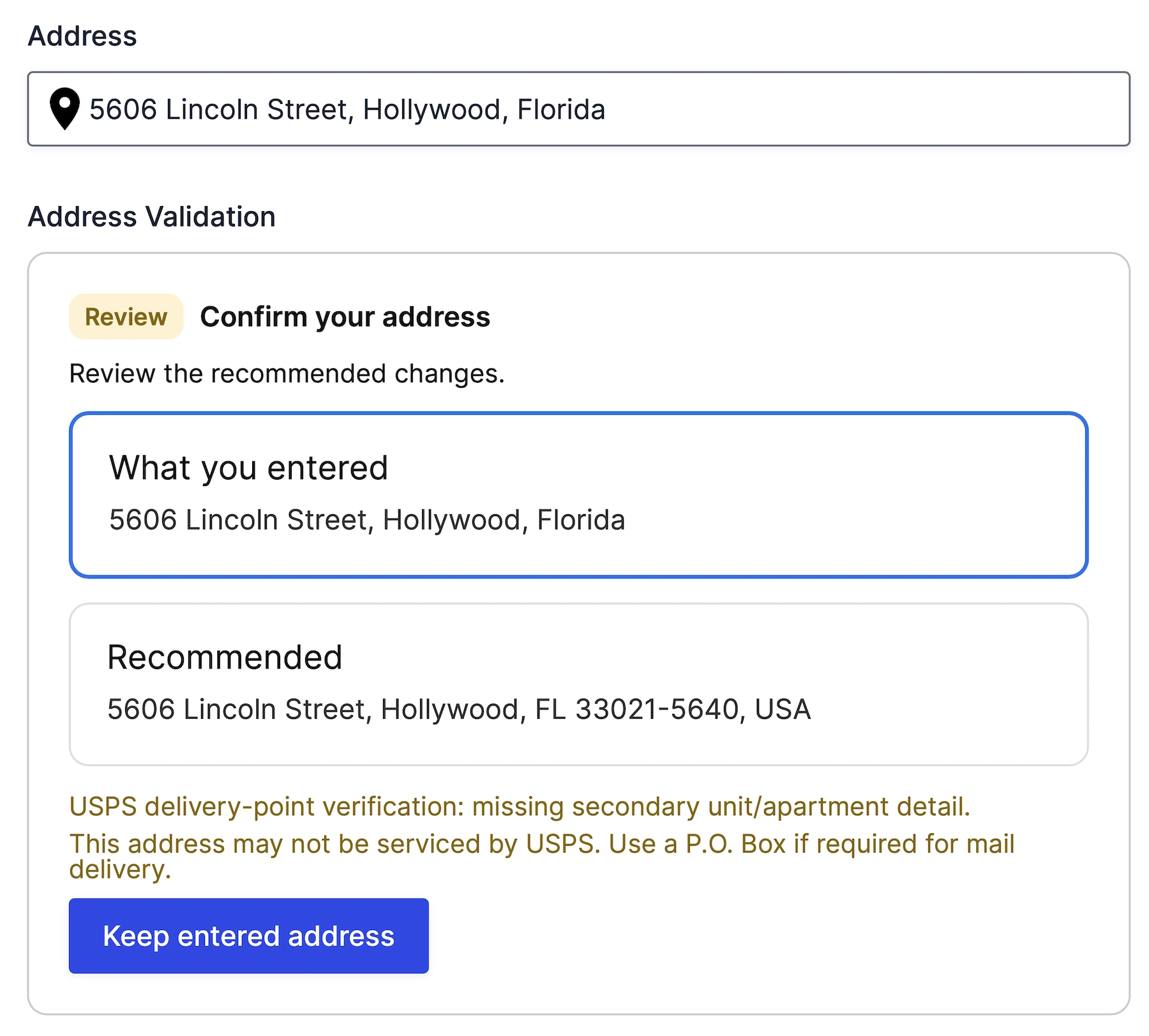
Validate & Verify Addresses Before Submission
- Reduce failed deliveries
- Verify address deliverability
- Standardize customer address data
- Give users control over suggested corrections
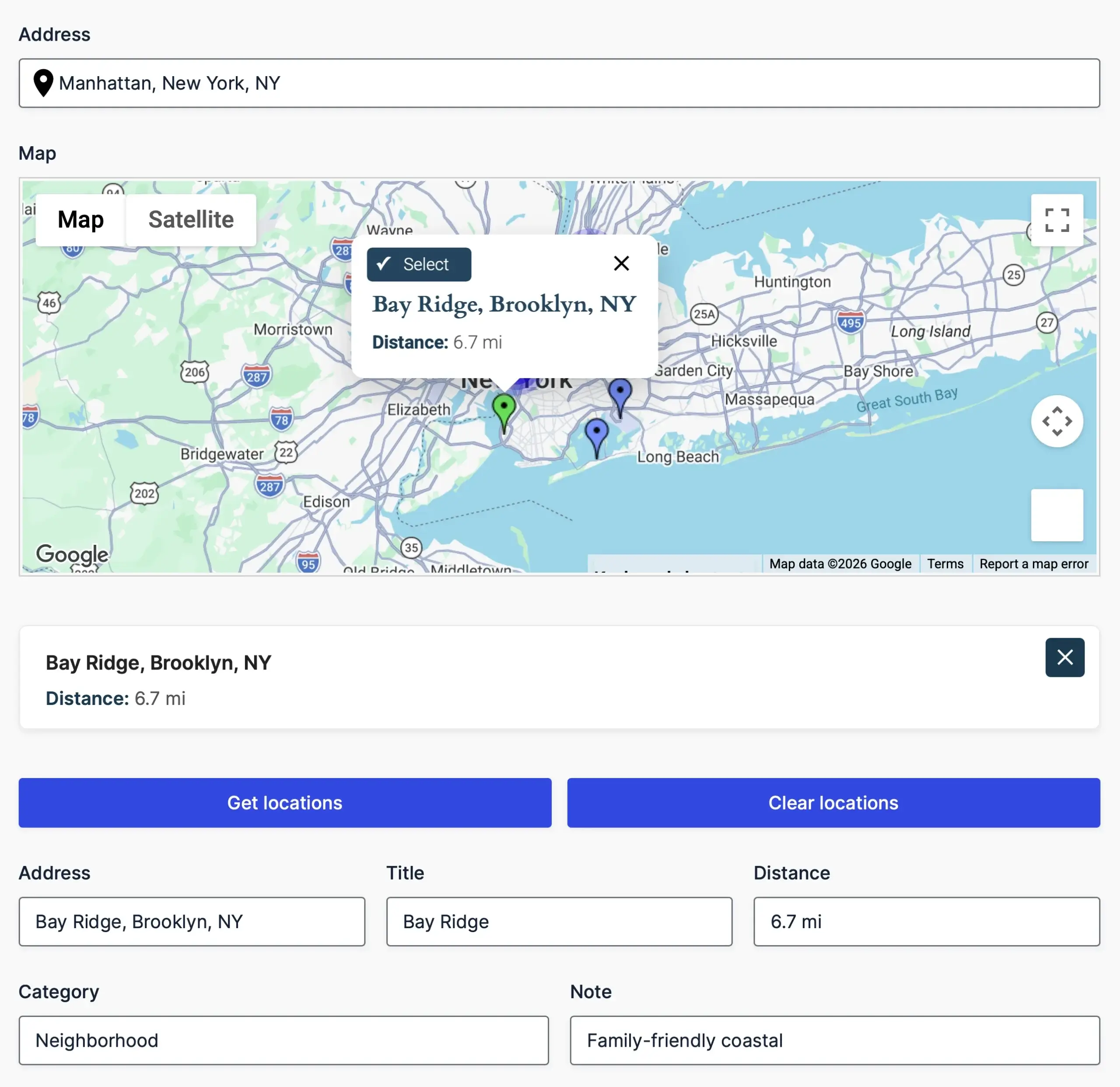
Find Nearby Locations Instantly
- Find the closest destination to any address or map location
- Compare locations using driving distance or radius calculations
- Load locations from manual lists, CSV/JSON files, or database tables
- Display matches on interactive maps with clickable markers
- Send selected locations directly into form fields and workflows
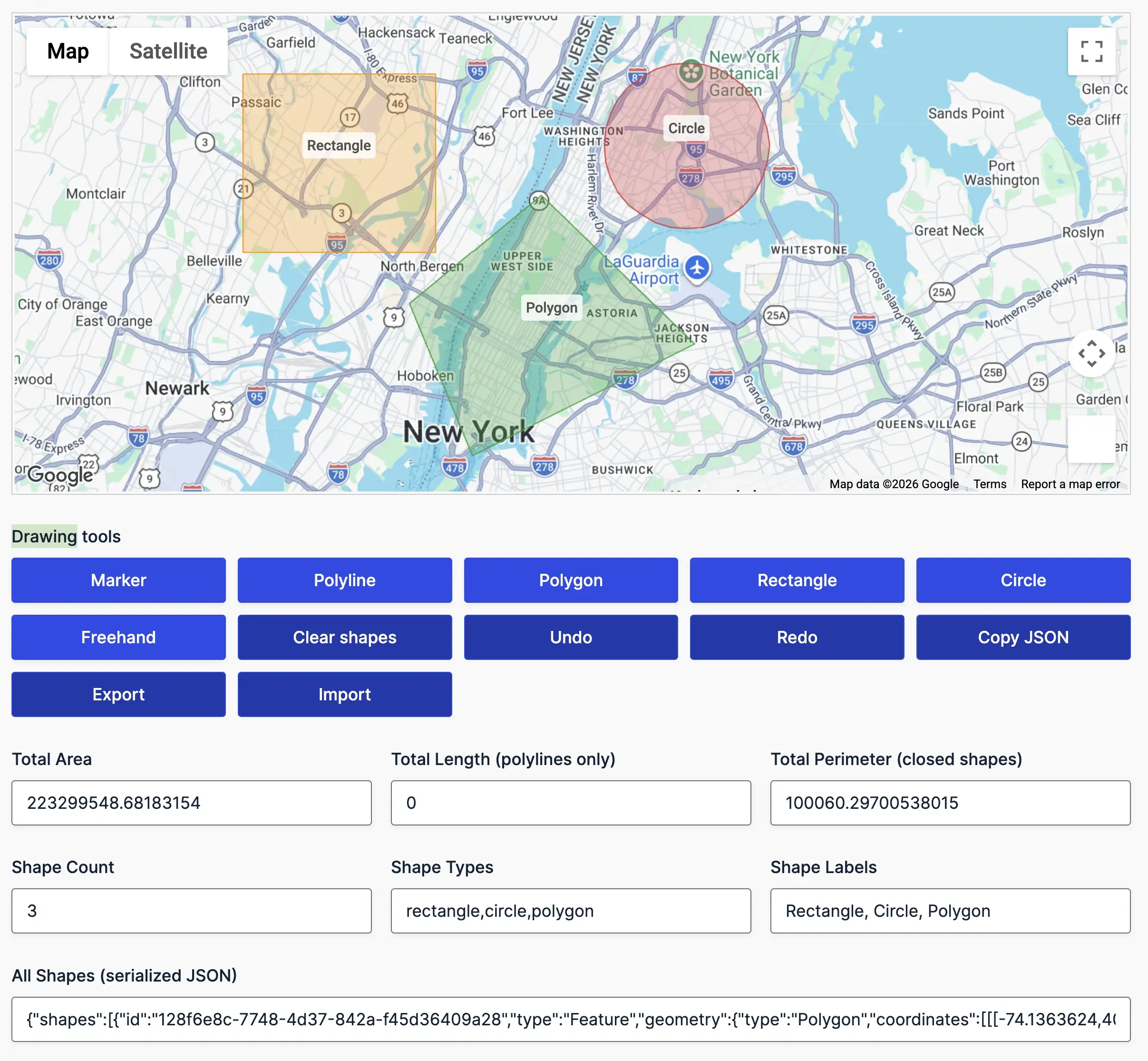
Define Service Areas & Boundaries
- Draw markers, polygons, circles, rectangles, polylines, and freehand shapes on a single map
- Resize, move, recolor, label, and manage shapes using the built-in editor panel
- Automatically calculate area, perimeter, length, radius, and center points in real time
- Import, export, and store shape data with form submissions for future use
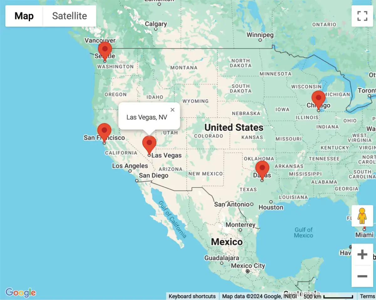
Visualize Locations on Interactive Maps
- Showcase multiple locations on a single, interactive map
- Perfect for displaying user submissions or store locations
- Easily visualize custom geolocation data collected through Gravity Forms
- Seamlessly embed maps on any page using a shortcode
Setting New Standards in Geolocation Solutions
Committed to excellence, raising the bar with every feature and update
Built with precision and care, our code meets industry standards to deliver secure, reliable, and adaptable solutions for your geolocation needs.
Engineered for flexibility, our code is easy to extend, customize, and integrate, equipped with hooks, filters, and a clean architecture for developers.
Our updates ensure your tools stay cutting edge, bringing new features, optimized performance, and compatibility with evolving platforms.
Try it with confidence. Explore the features for 14 days, and if it’s not the right fit for your needs, you’ll get a full refund.
Unlock the full potential of our tools with detailed documentation, offering step by step guidance and insights for every feature.
Our expert support team is always ready to assist, providing personalized solutions and ensuring you succeed at every step.
See It in Action - Try the Demo Now
Choose Your Plan to Unlock the Full Potential of Gravity Forms
Starter
.00
/First year
Pro
/First year
Agency
/First year
Special introductory pricing applies to the first year. Renewals are billed at the regular price. You can upgrade or cancel your plan at any time. Each plan includes automatic updates, premium support, and is backed by our 14-day money-back guarantee.
All purchases are securely processed on GEO my WP, our parent platform, where you can manage license, update, and support.